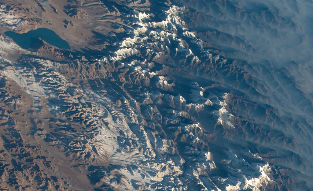
Lake Paiku sits 4,591 meters (15,062 feet) above sea level on the Tibetan Plateau, with Himalayan peaks of 5,700 to 6,000 meters rising around it, and it has nowhere to drain. Photos of the turquoise lake under snowy mountains reached the top of Reddit’s r/Damnthatsinteresting this week.
The lake, also spelled Pelku or Paiku Co, lies in Shigatse Prefecture in the Tibet Autonomous Region of China, about 18 kilometers south of the Yarlung Tsangpo, the river that becomes the Brahmaputra. It is 27 kilometers (17 miles) long and 6 kilometers wide at its narrowest point.
A lake with no exit
Paiku is endorheic: water flows in from glacier-fed streams and rain, but no river carries it out. The only way it loses water is evaporation. Most of the meltwater streams that tumble off the surrounding peaks soak into gravel and sediment before they ever reach the shore.
The basin’s lowest exit point is about 100 meters above today’s water level. If the lake ever rose that high, it would spill north into the Yarlung Tsangpo. Its water is brackish, slightly salty, which tells geologists it has not overflowed for hundreds and possibly thousands of years. Salt builds up when water leaves only by evaporation.
Deep, cold and shrinking
Paiku is also deep. NASA’s Earth Observatory, which published an astronaut photo of the lake taken from the International Space Station on February 19, 2022, describes an average depth of 41 meters. The northern half drops quickly to more than 70 meters (230 feet), while the southern half deepens more gradually to about 60 meters.
That depth works like a heat battery. Because Paiku stores more heat than shallow lakes, its water level follows an unusual rhythm:
- July to September (monsoon): evaporation stays low while rain and glacier melt pour in, so the lake rises fast.
- October to December: evaporation runs high and little water arrives, so the level drops sharply.
- Winter: ice covers much of the lake and the level barely changes, though the water underneath soaks up sunlight and releases that heat when the ice breaks.
Over the long run, Paiku is losing ground. Scientists estimate the lake has dropped about 4 meters since 1972, cutting its stored water by 8.5 percent. Spread over the 50 years to the 2022 photo, that works out to roughly 8 centimeters a year, about the width of a hand. NASA notes that many lakes in the plateau’s interior have grown, while southern lakes like Paiku, in a dry belt on the Himalayan slope, have shrunk.
Why the plateau’s lakes matter
Paiku is one of thousands of lakes on the Qinghai-Tibet Plateau, the largest and highest alpine lake system on Earth. The plateau is sometimes called the world’s largest water tower because it feeds rivers that supply fresh water to billions of people downstream.
The climate at the shore is harsh. Average daily highs stay below freezing in January, and the warmest months, July and August, average highs of about 12 to 13°C (54 to 55°F). About three-quarters of the roughly 298 millimeters of yearly precipitation falls between June and September.
Strange lakes are a regular stop for Badiyaa readers, from Australia’s bubble gum pink Lake Hillier to the Greenland fjord whose sloshing wave rang the planet for nine days. For the wettest spot on the continent, see Henderson Lake on Vancouver Island.
The figure to watch is that 100-meter gap: as long as Paiku stays far below its rim, it will keep getting saltier, one dry season at a time.
Further reading
Image: Earth Science and Remote Sensing Unit, NASA Johnson Space Center, Public domain via Wikimedia Commons
This article was produced with AI assistance and reviewed by our Editorial Desk. How we work.